2009 - Campaign Spring
The 2009 spring campaign on Tall Zar'a was carried out from the 3th March to the 15th April. In this season, excavations were carried out in Area I and Area II.
Area I (Late Bronze Age)
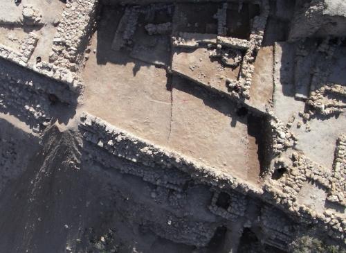
By 2008, the latest of the Late Bronze Age cities had been reached and exposed in approx. 1000 m2 of Area I. What was revealed was an impressive city ground plan at -22,90 m below sea level with several courtyard houses, two especially large house complexes (not yet excavated in their entirety), a small gate complex, a casemate wall and a tower with a sanctuary. In order to clarify the earlier architecture in this area, in 2009 the central part which was protected by the casemate wall was excavated to the next LB levels down.
In doing so, the long process of uncovering the stratigraphy of the tell, which in the coming years will lead all the way to the 4th millennium BC (Early Bronze Age), was continued. Terraced excavation on the western slope of Area I has enabled the measuring of the heights of the various levels (cf. the measuring point and Umayyad level at -17.04 m): the oldest Late Bronze Age level is at c. -24.50 m, the three Middle Bronze Age levels are at c. -25.40, -26.05 and -26.35 m, and, among several other levels, a 3 m-high Early Bronze Age fortification exists at -31.20 m.

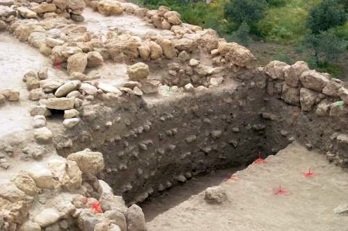
The big Nothing - layers of rubble under the casemate wall in the background: remains of the older LB strata after the landslide
Uncovering an ancient catastrophe
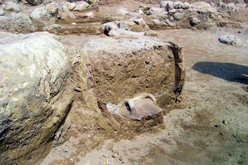
An older water drain and the inner face of slope fortifications were already visible under the later LB casemate wall that was removed this Spring. These structures were reached quickly, but were not, as previously assumed, part of a cohesive LB urban building complex, but rather the final phase of an elaborate renovation of the fortification structure in the western part of the city. Initially only a cobbled area around 8 m wide was visible inside the canal that led from one of the two very large house complexes to the downward drain. This was based on six consecutive layers of rubble 2.5 m thick that had been carefully stabilised and compacted using horizontal paving. On the slope side the paving opened out into a wide wall structure comparable to fortifications in its dimensions; however, because over 75% ceramics of the layers of rubble consisted of EB sherds, it would seem that it was brought up from the foot of the tell and used in the elaborate foundation work for the LB city. The very high city wall was successively reinforced by layers of rubble from behind. The very large LB house complex in the north of Area I (the excavation of which will be completed in 2010) was also carefully fortified using layers of rubble. It would seem from the fact that a tabun oven was even found on one of the layers of paving in this structure, that there must have been larger time intervals (the changing of the seasons?) between the construction of the various layers that enabled the top layer to compact and as such be strong enough to support next layers. Some of the paving layers were linked to minor architectural and functional features that we were unable to interpret.
 Rubble and paving layersin theprofil
on top: remains of water drains in the latest LBstratum
A major landslide that affected a large area far beyond the northern edge of Area I during the penultimate construction phase of the LB city was probably caused by an earthquake or flood. In any case, there was no indication of manmade destruction such as a siege. The remains of the older LB strata were, however, recoverable in the eastern part of Area I, and vividly tell the story of the catastrophe: severed walls, uprooted paving, rooms that had fallen down the slope. The enormous reconstruction effort described further above suggests that the ownership structures remained in place: the latest stratum that was excavated up until 2008 was built on two exterior walls that had survived the landslide and consisted of a courtyard house in the same place with a very similar ground plan to its predecessor, even including a stone-built oven in the same room. During the Spring campaign 2009, two further LB city layers could be identified in the same area that had been damaged by the landslide but were already destruction layers by this time. As a result, it is now possible to identify four successive LB cities in Area I.
Area I (Terraced excavation)
In order to clarify the context of excavation work in Area I it was necessary to continue and expand the terraced excavation of the western slope of the tell that was begun in 2005. In this area, under a MB(?) city wall, two further MB strata consisting of domestic structures that had already been discovered in 2006 were investigated. Of particular note is also the EB city wall that has now been excavated to a height of 3m. In the area of our terracing, this older wall was damaged by later (MB?) construction work: an elaborately constructed vertical water drain with its foundation ditch and shaft still intact break through the older wall in this area and can be seen bending down towards the slope in the excavation area.
Area I (Classical period and Iron Age IIB)
In Spring 2007 part of a very large house complex was uncovered in the northern part of Area I which was investigated further in 2008. This very elaborately constructed and, as we now know, also carefully grounded house is going to be excavated in its entirety. Various preparations for this were undertaken in Summer 2008 and in Spring 2009 excavation began, involving the investigation and removal of 725sqm of Umayyad, Roman-Byzantine, Hellenistic and Iron Age construction layers (similarly to the upper layers of the rest of Area I).
To this date an Umayyad house and a closed Roman-Byzantine settlement with rich finds have been uncovered. Of note is also the fact that in the newly excavated area, the Hellenistic phase contains not only the pits that are so common in Area I in this period, but also domestic structures similar to the ones already discovered and investigated in recent years in Area II. The Spring 2009 campaign also uncovered four well-built, stone-lined silos in the Hellenistic construction phase.

In Spring 2009 our dedicated team also reached the earliest construction phase of the Iron Age II in the northern part of the area, in which were found the remains of the city wall and several well-preserved tabun ovens, while the actual floor level was only reached in some areas. Two almost complete ovens with many layers of insulation around them were looked at in more detail and material samples were taken for archaeometric analysis. Surprisingly, 6 of the 14 ovens had a dome shape. The ash fillings of two of the ovens still contained multi-handled(!) pots. These will also be subjected to archaeometric analysis.
Of special note from the Spring 2009 season in Area I, apart from several fayence and metal finds and a further cylinder seal, are the coin and particularly the jewellery finds (e.g. pendants and pearls made ofdifferent materials).
Area II
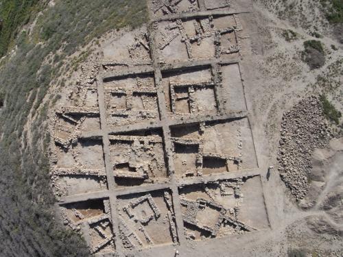
Area II has been excavated since 2006. Five strata with architectural remains could be identified. They can be dated from the Hellenistic to the Umayyad period. The focus of this spring campaign 2009 was lying on the clarification of the extension of the architectural remains of the different strata, especially of the large building of the third stratum which dates to the Roman-Byzantine period. All in all, 625 sqm were opened in this campaign and the whole area II has now an extension of 1575 sqm.

The oldest stratum 5 is represented by a large wall running east-west with a width of 2.2 m. For the time being, it has no connections to other remains on the site. It can probably dated to the Hellenistic period.
The next stratum (4)is characterized by architectural remains which are oriented south-west/north-east. At least four different phases of rebuilding could be differentiated. After destruction the houses were built up again on top of the former houses with a slightly different orientation so that the walls can be clearly differentiated. The houses are heavily disturbed by the later large building of the following period so that only small parts could be identified. This season, two almost complete houses could be excavated. They consist of one large room of about 5 m by 5 m. In the house at the eastern slope the entrance is recognizable and oriented to the southwest.
Because the houses of this stratum are not connected it is difficult to correlate the different building phases of one house with the others. However, the orientation of the architectural remains and the sequence of the phases clarify the interpretation in most cases.
The architecture of stratum 4 is cut by the large building complex of stratum 3. The architecture shows a completely different orientation, i.e. almost north-south. It consists of two parallel rows of large rooms and courtyards connected by a long courtyard or vestibule. This building can be dated to the Roman-Byzantine period.
After destruction - maybe by an earthquake - several architectural changes were made. In this case the still existing walls were reused and the building complex was enlarged by several rooms to the south, west and also in the east. These rooms are not constructed in continuation of the original plan but were set against the existing walls as needed. This leads to the change of a planned building complex to an agglomeration of rooms and courtyards. However, the orientation remains north-south. These changes can be dated to the late Byzantine period.
Stratum 2 is characterized by some reinforcements of walls of the older building of stratum 3 and a completely new building excavated in the west of area II. It is orientated southwest-northeast and consists of a large room measuring about 6 m by 6 m with an entrance to the northwest. This leads to another room which is situated in the southwest. This room could not be excavated completely. In a later building phase, a small room with a massive stone wall was set against the outer part of the northeastern wall. This stratum could be dated to late Byzantine or Umayyad period.
The upper most stratum 1 is characterized by pits. In some of them pottery of the Mameluk period could be found. However, the area has not been rebuilt since then.
Outlook
In Summer 2009 a survey of the Wadi al-'Arab is planned, which aims to shed light on the Classical and pre-Classical geographical context of the tell. In the Spring of 2010 and 2011 the most important desiderata up to the MB in Area I will be investigated, so that in 2012 the results of the excavation thus far can be published.
Problems
Unfortunately, there are ongoing problems with vandalism and other damage as a result of picnic activities and grave robbers. The guard at the site, who was provided by the Department of Antiquites, a fact for which we are very grateful, appears on some busy days to be unable to fully oversee the situation on his own, as a result of the growing number of visitors to the site.
Thanks
Our thanks go to all of the very generous institutions and individuals who support our work: the Department of Antiquities of Jordan for issuing the permits for our work, the Gerda-Henkel-Stiftung Düsseldorf for its generous support and also the Friends of the BAI Wuppertal and the GPIA Jerusalem/Amman for their long-term and consistent facilitation of our very successful work on the tell. We are also very grateful to our excavation workers and volunteers from the TM-Akademie Bensberg (near Cologne).
Last updated: 2009
|
CURRENT NOTE (2017) The results of the excavation campaigns from 2003 to 2011 are represented in detail in the final publication. |
 Close Window
 print
print